
Eagle Creek Hike
Eagle Creek Hiking Trail
by Andy P. of GorgeConnection.com
Eagle creek is a 4.2 mile round trip to if you're just heading in to see Punchbowl Falls (around 400 feet gain in elevation) or a 12 mile round trip if you decide to go to visit Tunnel Falls (about a 1300 ft gain but highly recommended). This is a VERY popular trail year round, so shoot for off days and times if you prefer a more serene hike. Going further will eventually connect you into a myriad of trails leading to all sorts of spots. This is however, definitately day trip territory now, if not multi-day.
Eagle Creek is Forest Service land as part of the Columbia Gorge National Scenic Area. This changes to the Mark Hatfield Wilderness section of the Mount Hood National Forest just about 5 miles up. Wilderness regulations apply from here on. For a list of those regulations, click here: Mark Hatfield Wilderness Regulations.
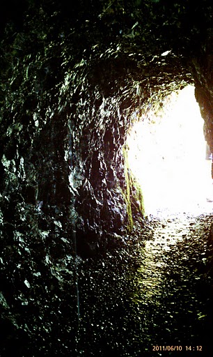
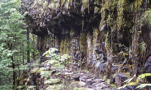
The Eagle Creek Trail was created by Italian engineers in the 1910s as they made their way up the Columbia River Gorge constructing the original highway. They dynamited away big sections of basalt, the evidence of which you can see once you get a few miles up the trail. They even drilled the hole in the rock behind Tunnel Falls that you go through.
A leisurely round trip into Punchbowl and back should take a couple hours. To Tunnel Falls and back is closer to 5 or 6 hours, depending upon your fitness level.
Directions: Coming from Portland, take I-84 west to exit 41. Coming from the east, take I-84 east to exit 40 then double back to exit 41. When you find a place to park, lock it up and dont leave any valuables. The lot has historically had trouble with break-ins. Before starting up the trail, be sure to buy a recreation pass at the parking lot and stick it in your window. Theyre only 5 bucks and the money goes to trail upkeep, so do the right thing.
The trail is open year round, but conditions will depend on rainfall and time of year. Going after a recent rain, you can count on many little tiny trickles of water coming off the sides of the hill, sometimes on to the trail. Eagle Creek is a steep canyon area, so the best time of day to hit it would be early to midday for the most sun, but then thats also when everyone else is going. It's not much of a wildlife trail, but if youre lucky you may see a deer or two coming out of the woods to drink at the waters edge. Most likely though, you will see a fair amount of birds of prey soaring about.
In addition to hiking, some good activities that are available along the trail are (many) picture taking, sunbathing, camping (only in designated areas) and swimming (in certain areas). Since there are numerous spots with long drop offs, this is NOT a trail for young kids. Dogs are welcome on the trail, but again, with the many cliffs, leashes are highly recommended.
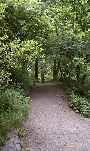
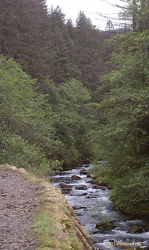
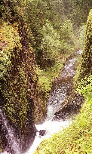
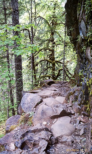
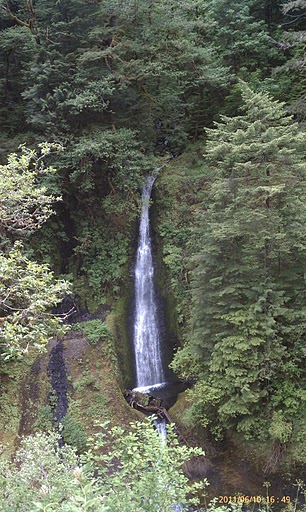
Starting off gradually from the parking lot, youre going to hug the creek through the only real open stretch of the hike. Before you know it (honestly, I was shocked how far Id climbed the first time I hiked it), the water will be a couple hundred feet below you. If you are heading up to Tunnel Falls, youll cover right around 1300 feet in elevation gain. Just after the two mile mark, youre going to come to the Punchbowl overlook. You can hike the trail down from there to a small rocky area if youd like to get the money shots (See my pictures below). Once youre down there, you kind of have to walk around a rock out cropping in order to get the full view of the falls. Depending on when you go, you might have to get a little wet to accomplish that, or a lot wet. Seasonal runoffs affect water levels. Later in the year, the lower the water usually.
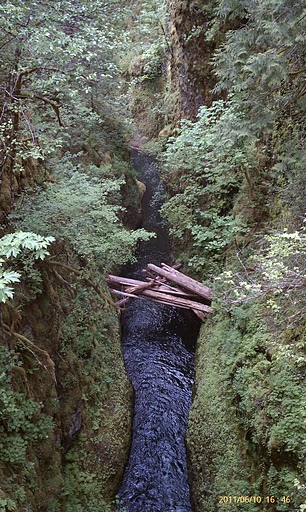
1.2 miles after Punchbowl comes High Bridge. Its a metal foot bridge (dont worry! It has rails!) over the narrowest part of the creek. Youll see why they named it High Bridge when you get there. As youre making your way up, keep an eye to the hills on either side of the creek for multiple different waterfalls of varying flows and heights. Some are named, and some will be seasonal runoffs.
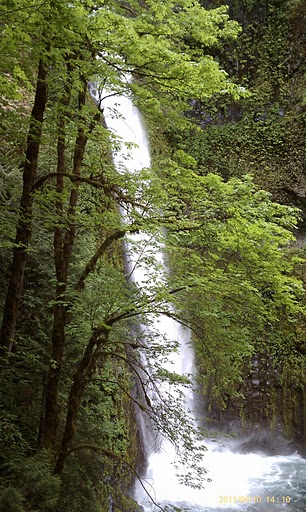
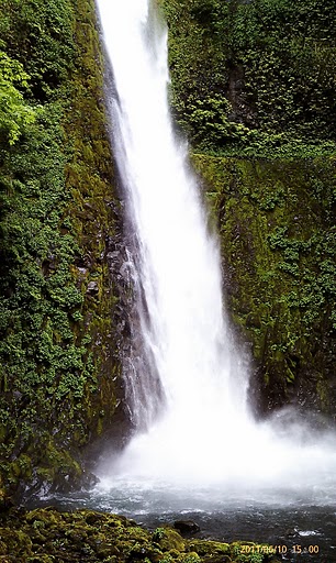
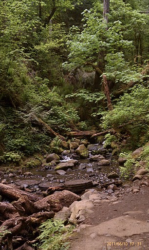
After a couple of miles and another bridge crossing (this one not nearly as vertigo-inducing), you should come around the payoff. Tunnel Falls slams down 175 feet to pool and flow downhill.
Take the requisite pictures, soak it all in (especially in the literal sense if you're close enough to the falls). If you REALLY just have a thing for waterfalls, you could keep going another couple of hundred yards and come to Twister Falls. Beyond that, I cant help you. At least until I come hike there again.There arent any "true" picnic spots on the trail but there are a couple right in the parking lot.. You should also be able to find a few spots to sit and munch riverside if you keep your eyes peeled.
For a celebratory meal upon returning to your car, head east on I-84 and either head to Columbia Gorge Hotel and their lovely happy hour from 4-7 every day of the week (4000 Westcliff Drive) or cross the Columbia River at Cascade Locks, continue east on Highway 14 to Stevenson, Washington, and stop at Walking Man Brew Pub (240 SW 1st Street) for a pint of their awesome Walking Man Brown Ale.
Title Link

"On The Lighter Side"
The Dalles Murals Loop - For those looking to take a stroll without inclines and wilderness. Located in downtown The Dalles, this 2 mile stroll is under rated to say the least!
Link